
The Santiago Creek Bike Trail (SCBT) is a paved multi-use trail that follows Santiago Creek through Santa Ana and Orange, with a convenient connection toward Villa Park. The City of Orange describes the main paved SCBT as approximately 6 miles long. The trail connects parks, neighborhoods and recreation areas while providing a mostly separated route for bicyclists, walkers and joggers.
Additional adjoining routes and unpaved trail segments can extend a trip beyond the official paved SCBT, including connections toward Villa Park, Santiago Oaks Regional Park and other Orange County trails.
Santiago Creek Bike Trail at a Glance
- Official paved trail: Approximately 6 miles
- Surface: Paved multi-use trail with some adjoining unpaved routes
- Uses: Bicycling, walking and jogging
- Hours: Dawn to dusk
- Major parks: Santiago Park, Hart Park, Yorba Park and Grijalva Park
- Villa Park access: Collins Avenue/Wanda Road area
- Eastern trailhead: Cannon Street staging area
- Western end: MainPlace/Santiago Park area near Santa Ana
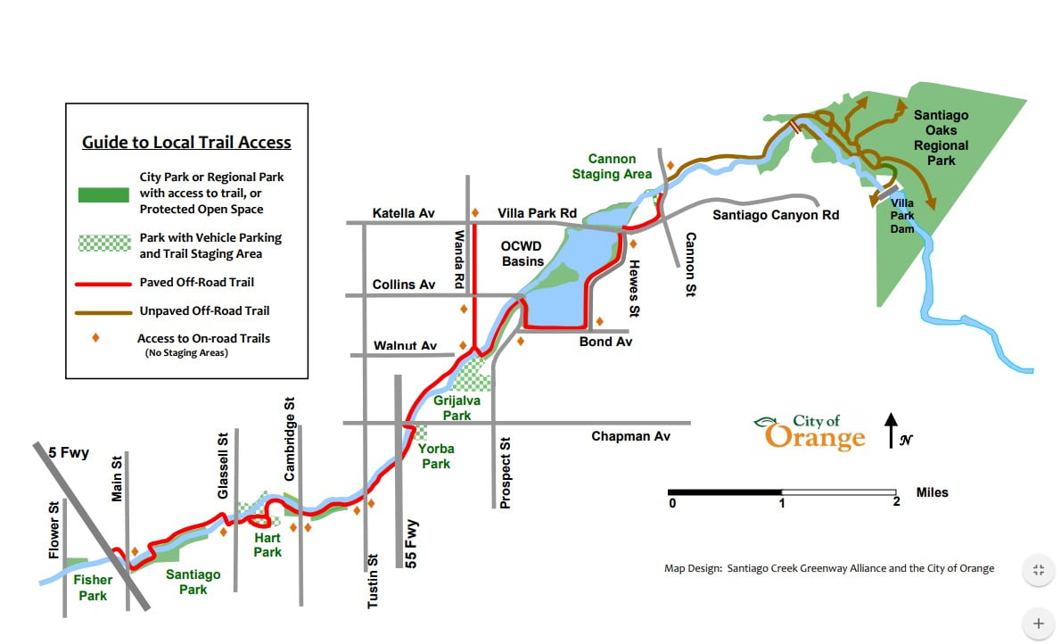
Santiago Creek Bike Trail Map
The City of Orange maintains current trail information, rules and access maps on its Trails and Bikeways page. You can also view the Santiago Creek Bike Trail map PDF hosted on VillaPark.co.
Santiago Creek Bike Trail Parking & Access Points
The trail has numerous neighborhood and street access points along with several locations where public park or staging-area parking is available. Public parks are generally the most convenient starting points because they may also provide restrooms, water and other amenities. The Cannon Street staging area has parking but limited amenities.
Major access points, listed generally from west to east, include:
- Main Street/Broadway area near Santa Ana and Santiago Park
- Glassell Street in Orange
- Hart Park
- Cambridge Street/La Veta Avenue
- Tustin Street/La Veta Avenue
- Yorba Park
- Bond Avenue/Prospect Street
- Hewes Street/Bond Avenue
- Hewes Street/Villa Park Road
- Grijalva Park
- Collins Avenue/Wanda Road near Villa Park
- Villa Park Road/Wanda Road
- Cannon Street staging area
Parking regulations and availability can change. Use designated public parking and observe posted signs rather than relying on private shopping-center parking.
Santiago Creek Trail Access from Villa Park
For Villa Park residents, one of the most useful connections is near Collins Avenue and Wanda Road along the Orange/Villa Park border. From the SCBT near Grijalva Park, an adjoining trail follows a former railroad right-of-way toward Wanda Road.
After reaching Wanda Road, riders and walkers can continue toward Villa Park Knowles and the Villa Park Town Center. Villa Park Knowles includes a landscaped walking path and fitness stations.
Dogs & Trail Rules
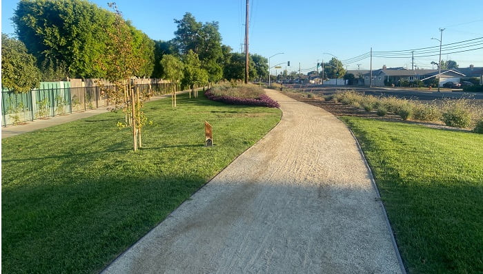
Dogs are permitted on the Santiago Creek Bike Trail but must remain on a leash no longer than 6 feet. Trail users and animals should remain on the designated trail and should not enter, wade or swim in Santiago Creek. The creek is a protected waterway. Dog-waste bag stations are available at some locations.
Yorba Park, located along the trail, includes a dog park with separate areas for small and large dogs.
Motorcycles, golf carts, unauthorized motorized vehicles, off-leash animals, horses and other prohibited uses are subject to posted trail rules. Check the City of Orange’s current trail rules before visiting.
Features of the Santiago Creek Bike Trail
- Multiple neighborhood and park access points
- Mostly separated from vehicle traffic
- Scenic creek and riparian habitat
- Suitable for families, walkers, joggers and recreational cyclists
- Generally gradual terrain that works well for casual riders
- Connections to parks, recreation facilities and neighborhoods
- Pedestrian bridges and roadway undercrossings along portions of the route
- Access to several Orange County historical and natural sites
Santiago Creek Bike Trail Guide
This guide follows the trail upstream from the Santa Ana/MainPlace area east and northeast through Orange to the Cannon Street staging area. You can also explore historic sites along Santiago Creek.
Santa Ana & MainPlace Area
The western end of the paved trail is near Broadway and MainPlace Drive in Santa Ana, close to MainPlace and Discovery Cube. From here, the route heads east along Santiago Creek toward Santiago Park.
Santiago Park
The trail enters Santiago Park, a linear park along the creek with recreation areas and trail access. Depending on current facility availability, the park can provide a useful rest or access point before continuing east.
Hart Park – City of Orange
The trail continues beneath SR-22, passes the Glassell Street access area and enters Hart Park. Hart Park offers parking, restrooms, picnic areas, playgrounds, sports facilities and other amenities. The trail runs through the park before reconnecting with the creek corridor.
Cambridge Street & Tustin Street
East of Hart Park, the trail passes access points near Cambridge Street and La Veta Avenue before continuing toward Tustin Street. This portion includes landscaped trail sections, bridges and roadway undercrossings.
Tustin Street to Yorba Park
The route continues along Santiago Creek and passes beneath SR-55 on the way to Yorba Park. This section provides a largely separated creekside route through an urban area.
Yorba Park
Yorba Park provides trail access, parking, restrooms, walking paths and a dog park. A historical marker at the park notes the Portolá Expedition’s 1769 camp along Santiago Creek.
Yorba Park to Grijalva Park
Continuing east, the trail crosses a pedestrian bridge and heads toward the Chapman Avenue underpass. Mature native trees and creek habitat line portions of this section. The grade increases gradually as the route approaches Grijalva Park.
Grijalva Park
Grijalva Park is another useful trail access and rest point. The surrounding creek habitat may support ducks, turtles, frogs, waterfowl and other wildlife depending on water and seasonal conditions. The park also includes recreation facilities and outdoor fitness equipment.
Grijalva Park to Villa Park
Near Grijalva Park, trail users can branch toward Collins Avenue and Wanda Road. This adjoining route follows a former Southern Pacific railroad right-of-way that once served local agricultural operations. It provides a convenient connection toward Villa Park Knowles and the Villa Park Town Center.
Collins Curve & Bond Avenue
Continuing on the main route toward Cannon Street, the trail follows the creek near Grijalva Park before curving toward Bond Avenue. This area is sometimes referred to locally as Collins Curve.
Santiago Creek Recharge Basins
Along Bond Avenue, the route passes the Santiago Creek Recharge Basins. These basins capture and store stormwater and other water supplies so water can percolate into the Orange County Groundwater Basin. Viewing openings along portions of the barrier provide glimpses of the basins, but visitors should remain on the designated trail and observe posted safety signs.
From the basin area, the route continues near Hewes Street and Villa Park Road before heading toward Cannon Street.
Cannon Street Staging Area
The stretch between Villa Park Road and Cannon Street includes some of the more natural scenery along the paved trail, with views of Santiago Creek, wetlands and surrounding habitat. The Cannon Street staging area marks the eastern end of the main paved SCBT and includes a gravel parking area with limited amenities.
Continuing to Santiago Oaks Regional Park
The paved Santiago Creek Bike Trail should be distinguished from the unpaved recreational trails farther upstream. Walkers, hikers and appropriately equipped cyclists can use trail connections that continue toward Santiago Oaks Regional Park, the Villa Park Dam area and other regional trails.
Santiago Oaks contains riparian woodland along Santiago Creek as well as grassland and coastal sage scrub in the surrounding hills. Trail conditions and permitted uses vary, so check current park information before continuing beyond the paved SCBT.
Does the Santiago Creek Trail Connect to the Santa Ana River Trail?
The paved Santiago Creek Bike Trail does not currently provide a simple, fully continuous paved connection directly into the Santa Ana River Trail. Near the western end, trail users should consult current City of Orange, City of Santa Ana and regional bikeway maps before attempting to connect between the two routes because trail alignments and street connections can change.
Future Santiago Creek Trail Improvements
The City of Orange has been planning for the long-term future of Santiago Creek. The Orange City Council approved the Santiago Creek Strategic Plan on February 24, 2026, following work by the Santiago Creek Commission and community stakeholders. The plan addresses the creek corridor as a whole, including trail connectivity, access, recreation, habitat and other potential improvements.
Future projects are subject to funding, design, environmental review and City approval. For the latest planning information, visit the City of Orange’s Santiago Creek Strategic Plan information.
Connecting Bike Routes
Several streets and bikeways can help cyclists reach or leave the Santiago Creek corridor, including portions of Santiago Canyon Road, Cannon Street, Chapman Avenue, Jamboree Road and other designated bicycle routes. Because bike-lane classifications and routes can change, consult current City of Orange bikeway maps before planning a street connection.
Santiago Creek Bike Trail FAQs
How long is the Santiago Creek Bike Trail?
The City of Orange describes the main paved Santiago Creek Bike Trail as approximately 6 miles long. Additional adjoining routes and unpaved trails can extend a trip beyond the official SCBT.
Where does the Santiago Creek Bike Trail start and end?
The main paved route runs from the Santa Ana/MainPlace and Santiago Park area east through Orange to the Cannon Street staging area. Additional trail connections extend toward Villa Park and Santiago Oaks Regional Park.
Is the Santiago Creek Bike Trail paved?
Yes. The main SCBT is a paved multi-use trail. Unpaved recreational trails continue beyond portions of the paved route, particularly toward Santiago Oaks Regional Park.
Where can you park for the Santiago Creek Bike Trail?
Public parks such as Hart Park, Yorba Park and Grijalva Park are useful access locations, and the Cannon Street staging area also has parking. Always follow posted parking rules.
Can dogs use the Santiago Creek Bike Trail?
Yes. Dogs are permitted but must remain leashed, and both people and animals should stay out of Santiago Creek and follow posted trail rules.
Does the Santiago Creek Bike Trail connect to the Santa Ana River Trail?
Not through a simple, fully continuous paved connection. Check current local and regional bikeway maps when planning a route between the SCBT and Santa Ana River Trail.