
Santiago Creek is more than a recreational corridor. Its history reflects centuries of Indigenous presence and later Spanish exploration, ranching, irrigation, agriculture, transportation, mining, flooding and recreation in what became Orange and the broader Villa Park area. Today, the Santiago Creek Trail passes near many places connected to that history.
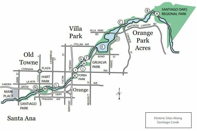
Not every historic site listed below is still visible. Some are former sites, archaeological locations or approximate locations identified through historical accounts. Several are on or near private or restricted property, so they should be viewed only from public trails, parks and roads. The letters below correspond to the map and generally follow Santiago Creek from the Santiago Oaks area westward.
Santiago Creek Historic Sites Map
A. Santiago Oaks Water Diversion Dam
Near Santiago Oaks Regional Park is the site of an early water-diversion structure traditionally dated to about 1890. The submerged remains are part of the larger story of how Santiago Creek water was diverted and managed as agriculture expanded across the region. The feature is a historic site rather than a conventional visitor attraction and may not be readily visible.
B. Camp Jotham Bixby – Early Boy Scout Camp
The Santiago Oaks vicinity was once associated with Camp Jotham Bixby, an early Orange County Boy Scout camp dating to around 1921. Historical accounts have described it as Orange County’s first Boy Scout camp. The camp itself is a former site; visitors should not expect a surviving camp complex along the modern trail.
C. Grijalva Hide-Tanning Vats
Historic accounts place hide-tanning vats on the north side of Santiago Creek below the Cannon Street bridge. They were associated with the cattle-ranching era of Rancho Santiago de Santa Ana and illustrate the economy that preceded the region’s later citrus boom. Much of the physical evidence was reportedly damaged or destroyed by the major 1916 flood.
D. Grijalva Adobe at Hoyt Hill
East of Hewes Street and Rancho Santiago Boulevard is the historic site associated with the Grijalva Adobe. The adobe is traditionally dated to the early 1800s. A later Victorian-era residence was built at the site in 1887, and historical accounts report that a remnant of a rock foundation is all that remains of the earlier adobe. This is a historic location, not a public archaeological attraction, and private property should be respected.
E. Santiago Creek Sand and Gravel Pits
Sand and gravel extraction substantially altered portions of the Santiago Creek corridor during the 20th century. Historical references associate several operations and names with these pits, including Conrock, Blue Diamond and Bond. Former extraction areas later became part of the region’s water-management and groundwater-recharge system. Because operators and dates changed over time, these names should be understood as parts of a longer industrial history rather than as a single continuous operation.
F. Southern Pacific Tustin Branch
The Southern Pacific Railroad’s Tustin Branch crossed the Santiago Creek area north of Walnut Avenue. Tracks were laid during the late 1880s as railroads increasingly served agricultural communities and fruit-packing operations. Flooding in 1969 destroyed creek-area railroad infrastructure. This was a Southern Pacific line and should not be confused with the later Pacific Electric railway system.
G. Patterson Bowers Orange Grove
Near the end of Walnut Avenue, north of Santiago Creek, historical accounts identify a grove planted by Patterson Bowers around 1872 as an important early orange grove in Orange. The site represents the beginning of the citrus economy that would eventually transform the landscape around Orange and the historic Villa Park district. Claims that it was the absolute first planting should be treated cautiously because historical descriptions vary.
H. Portolá Expedition and Santiago Creek
Historical accounts place the 1769 Portolá expedition near Santiago Creek in the vicinity of today’s Grijalva Park, although the exact campsite is unknown. Fray Juan Crespí’s expedition diary is an important source for the Spanish-era description and naming of places encountered along the route. The expedition did not mark the beginning of human history here: Indigenous communities lived in and used the region long before Spanish exploration. The map marker should therefore be read as an approximate historical reference, not a precisely located campsite.
I. The Lost Town of McPherson
McPherson was a short-lived community established during the Southern California land boom of the 1880s. The townsite dates to about 1886, when grapes were an important local crop. Development patterns changed as the boom faded and agriculture evolved, and McPherson largely disappeared as a recognizable town. The site is best understood through historic maps and records rather than surviving town buildings.
J. Orange, McPherson & Modena Street Railway
The Orange, McPherson & Modena Street Railway was created during the boom years of the 1880s and originally operated as a horse-drawn street railway. Its route crossed the Santiago Creek area near Chapman Avenue. Flooding in the early 1890s damaged the line and helped bring its brief operation to an end. This railway was distinct from both Southern Pacific and Pacific Electric.
K. Flippen Ranch – Yorba Park Area
The map identifies the Flippen Ranch in the Yorba Park area, preserving the name of a ranching family associated with this part of the creek corridor. The surviving page documentation does not establish enough detail to state the ranch’s exact boundaries, dates or agricultural operations with confidence, so the location is presented as a historical reference rather than a precise property reconstruction.
L. Santa Ana Valley Irrigation Company Aqueduct
The Santa Ana Valley Irrigation Company (SAVI) carried water through the area historically known as Sycamore Crossing, near the former Santiago Golf Course. Irrigation systems tied to Santiago Creek were essential to the growth of orchards and farms across Orange and the broader Villa Park agricultural district. William Blasdale, an early Orange-area rancher whose former home was later moved to Villa Park, was among the local figures involved with SAVI. Water rights and irrigation are central to understanding how the region developed.
M. William O. Hart Park
William O. Hart Park developed from Orange’s early municipal park and became an important recreational space along Santiago Creek. Historical features include creek rockwork associated with Depression-era public works. The park was also connected with the Lionettes, a women’s softball team, adding a sports-history chapter to the creek corridor.
N1. Orange’s Early Chinatown
Historical accounts place a Chinese community on the north side of Santiago Creek below Glassell Street from roughly the 1890s into the early 20th century. Its history belongs within the larger story of Chinese residents, workers and businesses in early Orange County. The settlement no longer survives as a visible neighborhood, and its location should be treated as a historical site rather than a destination with standing structures.
N2. Indigenous Archaeological Site
Historical accounts report Indigenous artifacts in the same general Santiago Creek area. Artifact finds demonstrate earlier Indigenous use of the landscape, but they do not by themselves establish the exact boundaries or nature of a permanent campsite. The location is approximate, and archaeological resources should never be collected, disturbed or removed.
O. Major Santiago Creek Floods
Flooding repeatedly reshaped Santiago Creek and damaged roads, bridges, rail lines and other infrastructure. Historical flood years associated with the creek include 1825, 1861–62, 1884, 1916, 1938 and 1969, although the scale and documentation vary from event to event.
The 1969 floods are especially well documented in the Villa Park area and connect several parts of the local story: Santiago Creek, Villa Park Dam, the Santiago Boulevard crossing and Station 23 and Villa Park fire-service history. Floodwaters washed out the Santiago Boulevard bridge over Santiago Creek, forcing Villa Park fire crews into a lengthy detour for some calls. Orange County later approved a temporary creek crossing for emergency equipment. Earlier floods also affected historic creek features, including transportation infrastructure and remnants associated with the ranching era.
Santiago Creek and Villa Park History
Santiago Creek runs largely outside the boundaries of today’s small City of Villa Park, but it was fundamental to the history of the broader Villa Park agricultural district. Water from the creek supported irrigation systems and orchards, while disputes over water rights helped shape regional development. The creek also influenced transportation routes, flood-control projects and local fire response.
This geographic distinction matters when reading old records. Before Villa Park incorporated in 1962, references to “Villa Park,” the “Villa Park district” or the “Villa Park section” could describe a larger community than today’s municipal boundaries. Historic creek sites should therefore be located according to the evidence rather than automatically treated as places within the modern city.
Related local history: Villa Park History, Villa Park Fire History, Villa Park Dam and the Santiago Creek Trail.
What Can You Still See Along Santiago Creek?
The modern trail provides access to the creek landscape and several public parks, but many of the historic places on this map are sites rather than surviving landmarks. Rail lines, townsites, ranch features and early industrial structures have disappeared or been altered, while some archaeological and historic locations are approximate or lie near private property.
Use the map as a historical guide rather than as directions to enter individual sites. Public places such as Santiago Oaks Regional Park, Grijalva Park and William O. Hart Park provide the easiest way to experience the creek corridor. Historic and archaeological resources should be observed from legal public access points and left undisturbed.
Understanding the Creek’s History
The locations above span very different periods and types of evidence. Some are documented structures or transportation routes, while others are approximate sites reconstructed from maps, newspapers, diaries and later historical accounts. Dates described as “about” or “circa” should be understood as approximate.
For additional regional history, OC Historyland is a useful secondary resource. Primary and authoritative records—including historical newspapers, government water and flood-control records, railroad sources and early expedition accounts—are preferable when establishing exact dates, locations and claims.