
Villa Park is a small incorporated city in Orange County, California, largely surrounded by the City of Orange. The city has no freeway within its boundaries; nearby SR-55 provides the primary north-south freeway access, with connections to I-5, SR-22, SR-57 and SR-91. This guide provides a modern Villa Park map, major access routes, nearby airports and train stations, and an important explanation of how today’s city boundary differs from the broader historic Villa Park District.
Villa Park CA Map
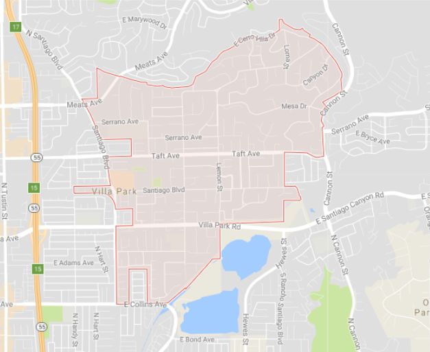
Modern City vs. Historic Villa Park District
Today’s City of Villa Park should not be confused with the broader historic Villa Park District. Before Villa Park incorporated on January 11, 1962, the name was used for an agricultural community that extended beyond the boundaries of the modern city. As a result, historical newspapers and records may describe ranches, residents, businesses and events as being “in Villa Park,” “at Villa Park,” in the “Villa Park section” or in the “Villa Park District” even when the location would today be in Orange or another area outside Villa Park’s incorporated boundary.
When VillaPark.co discusses pre-1962 Villa Park history, we distinguish the historic district from the modern city whenever the location can be determined. The exact historic district was not a modern surveyed municipal boundary, so this site does not assign a precise historic boundary where the surviving evidence does not support one. See the History of Villa Park for more background.
Why Historical Villa Park Locations Can Be Confusing
Several historical examples show why modern city boundaries should not be applied automatically to older Villa Park references. Cerro Villa Heights was a named citrus subdivision that contemporary 1920 reporting described as north of Villa Park, rather than simply an informal name for today’s northeastern city. Adolphus Ranch was historically associated with Villa Park and the broader Villa Park District but was not within the incorporated City of Villa Park. Likewise, a property could carry a Villa Park name or community association while lying outside the modern city. Historical geography is therefore evaluated from the location evidence available for each site rather than from the name alone.
Villa Park Today
The incorporated City of Villa Park covers about 2.1 square miles and is closely associated geographically with the City of Orange, which surrounds most of it. Other Orange County cities such as Anaheim, Santa Ana and Tustin are nearby but should not be confused with Villa Park’s immediate municipal geography. In some locations the transition between Orange and Villa Park may not be visually obvious, making a municipal boundary map more useful than neighborhood appearance alone.
Villa Park, CA 92861 is also a postal description, not a historical boundary definition. Municipal boundaries, ZIP codes, school attendance areas and the historic Villa Park District are different geographic concepts and should not be treated as interchangeable.
Getting to Villa Park
Villa Park has no direct freeway frontage. SR-55 is the nearest major north-south freeway and connects with regional routes serving Orange, Los Angeles, Riverside and San Bernardino counties. Rather than relying on fixed travel times or turn-by-turn directions that can quickly become outdated, visitors should use current navigation and traffic information for their specific destination.
Major Roads and Freeway Access
- SR-55: Primary nearby north-south freeway access.
- I-5: Regional access toward Los Angeles, Santa Ana and San Diego.
- SR-22: East-west access across central Orange County.
- SR-57: Access toward northern Orange County and eastern Los Angeles County.
- SR-91: East-west access toward Riverside County and northern Orange County.
- Local approaches: Katella Avenue, Santiago Boulevard, Wanda Road, Lincoln Avenue and Taft Avenue are among the important streets used to reach and travel around Villa Park.
For a useful central destination, see the Villa Park Town Center, which includes City Hall and other community services.
Airports Near Villa Park
Airport travel times vary substantially with Southern California traffic. Check live traffic and navigation before departure.
- John Wayne Airport (SNA) — the most convenient major commercial airport for many Villa Park trips.
- Long Beach Airport (LGB) — another Orange/Los Angeles County regional option.
- Ontario International Airport (ONT) — useful for some Inland Empire and eastern travel itineraries.
- Los Angeles International Airport (LAX) — offers the broadest range of flights but travel time can vary greatly.
- Hollywood Burbank Airport (BUR) — a farther alternative that may be useful depending on flight availability and destination.
Train Stations Near Villa Park
Villa Park does not have a passenger rail station. The Orange Transportation Center is one of the closest and most locally relevant stations. Other nearby stations provide combinations of Metrolink commuter rail and Amtrak Pacific Surfliner service. Because schedules and service patterns change, verify current service before traveling.
| Station | City | Service |
|---|---|---|
| Orange Transportation Center | Orange | Metrolink; check current Pacific Surfliner service |
| Anaheim Regional Transportation Intermodal Center (ARTIC) | Anaheim | Metrolink and Pacific Surfliner |
| Santa Ana Regional Transportation Center | Santa Ana | Metrolink and Pacific Surfliner |
| Fullerton Transportation Center | Fullerton | Metrolink and Pacific Surfliner |
| Irvine Transportation Center | Irvine | Metrolink and Pacific Surfliner |
| Tustin Station | Tustin | Metrolink |
Villa Park Historical Geography FAQ
When did Villa Park become a city?
Villa Park incorporated on January 11, 1962.
Was the historic Villa Park District the same as today’s city?
No. The historic Villa Park community or district was broader than the incorporated city. Historical references should not automatically be mapped to today’s municipal boundaries.
Why do old newspapers describe places outside today’s city as Villa Park?
Before incorporation, Villa Park was a community and agricultural district rather than a city with today’s municipal boundary. Newspapers therefore used “Villa Park” for a broader geographic area.
What was Cerro Villa Heights?
Cerro Villa Heights was an early citrus subdivision. Contemporary 1920 reporting described it as north of Villa Park, so it should not simply be equated with the northeastern portion of today’s city.
Was Adolphus Ranch inside the City of Villa Park?
No. Adolphus Ranch was historically associated with Villa Park and the broader Villa Park District, but it was not within the incorporated City of Villa Park.
Does a Villa Park mailing address establish the city boundary?
No. Postal geography, ZIP codes, municipal boundaries and historical community boundaries serve different purposes and should not be treated as identical.